Daily
Weather Newsletter
March 6,
2013
Good
Morning,
A
cold front, currently along the East Coast, swept through our region
yesterday. The front brought in clearing
skies, lots of wind and cooler temperatures.
This pattern of warm, cold, warm and cold will continue through the
coming weekend, with Sunday and Monday being wet and possibly wild weather days
for parts of the Southeast.
Surface Analysis
The
cold front is part of a larger system, that has a Low pressure center over
Virginia and another over Ohio. These
pressure systems will continue to develop, and lots of snow and rain is
scheduled from Maryland through the Northeast today and tomorrow.
With
at least 2 more large snow-producing systems in the near-term future for the
Northeast, folks in that part of the country may wonder if the snow will ever
stop. Conversely, places like Chicago,
Omaha and other Midwest cities have barely received 1/2 of their normal
snowfall for the winter. The drought
continues to worsen for the Midwest and Great Plains.
Temperatures
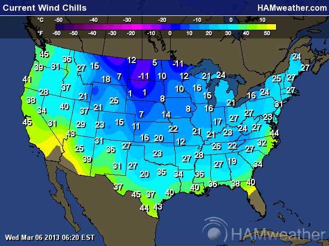
across most of the United States are chilly this morning. A quick look at the Wind Chill map and it
shows a similar pattern to last week's Wind Chill chart.
It's
not often that you see Wind Chill temperatures of 40 degrees or less, reaching
all the way to the Gulf Coast in the first week of March on 2 different
occasions. But then again....welcome to
the "new" normal.
Wind Chill Map
I
was listening to a radio program yesterday and several broadcast meteorologists
were wishing that the entire Groundhog's Day myth would end. These meteorologists were stating how their
listeners were constantly wondering why isn't the weather following the
groundhog's prediction.
It's
a groundhog...why would anyone think a groundhog has any clue to the weather
patterns? I understand the entire
Groundhog's Day event is steeped in folklore, but just because something is old
and based upon perception, doesn't mean it's right. I agree 100% with the broadcast
meteorologists. Let's drop Groundhog's
Day...it's a waste of time.
Enough
about furry rodents, let's move on to the Weekend Peek for the Southeast.
The
Southeast will begin the slow warm-up through the weekend, and we will see some
very warm temperatures on Sunday and Monday in locations throughout the
Southeast. Then another cold front comes
through, beginning on late Saturday in Texas.
There will be rain and thunderstorms in Texas and Louisiana.
By
Sunday, the cold front will cause rain and thunderstorms throughout most of the
Ohio River Valley, down to Houston.
Chances for severe weather along the Mississippi River Valley are
diminishing, but not fully eliminated. I
will continue to monitor this area.
When
Monday arrives, it's a pattern we are familiar with...clearing skies and cooler
temperatures in the western portion of our region, while the cold front is
along the East coast bringing warm temperatures with clouds and
thunderstorms. Next Tuesday, all of the
Southeast will be enjoying partly cloudy skies and cooler temperatures...and
the roller coaster starts all over again.
Yesterday
I stated that I saw a map from The Weather Channel that depicted temperatures
"well below normal" for much of the Southeast for March. The main thrust of the cooler weather will be
centered along a line from St. Louis to Savannah Georgia...the same axis that I
spoke about almost 5 weeks ago.
Yes,
the entire Southeast will experience the roller coaster "effect" for
March, but the coldest temperatures will be along the stated axis. On the flip side, a dramatic change in the
jet stream pattern will occur in April, and the Southeast will go from
"well below normal" to a situation of "well above normal"
for temperatures. The strange weather
continues.
That's
it for now...have a sunny day.
Rocco


Add a comment